 The
Storm From Seabee Hill
The
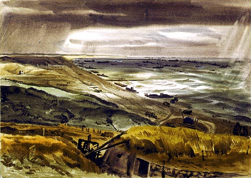
Storm From Seabee HillMitchell Jamieson #232a
Watercolor, June 1944
88-193-IK
The weather was always an unknown factor. Storms in the English Channel have always been violent, with the wind whipping the waves in the confined area between Normandy and England. The great storm of June 19-20 succeeded in doing what the Germans had not been able to do - destroy the great "mulberry" artificial harbors.
The
Storm From Seabee Hill
Mitchell Jamieson #232a
Watercolor, June 1944
88-193-IK
From this spot, where the Seabees had their camp, one could look down and see disaster in the making. This view looked east along the Omaha sector, at the scores of amphibious craft and pontoons, at the causeways and barges gradually being pounded and ground into pieces. The Seabees helplessly watched their work down below being wrecked beyond hope. This was the beach where resistance was so fierce and losses were heaviest on D-Day. A look at the terrain reveals why. The entire beach was commanded from these heights by casemated guns, mortar pits and machine gun nets. The wrecked field gun in the foreground was one of many such used from pillboxes under several feet of concrete and connected by tunnels and other emplacements. Concrete mortar pits were a few yards to the left of this picture, sunk about seven feet into the ground. Each was provided with small painted views around the top of the interior corresponding with the actual view in every direction, marked with the range so that the gunner could lay his shells where he wanted without exposing himself. Directly below was one of the road exits from the beach, muddy and almost impassable. Beyond could be seen the tank ditch running parallel with the shoreline - the ground started to rise in varying degrees of abruptness on the landward or left side of the ditch. Barbed wire was strung all along here and there was practically no cover for the attacking troops who stormed these defenses.
 The
Storm from Seabee Hill
The
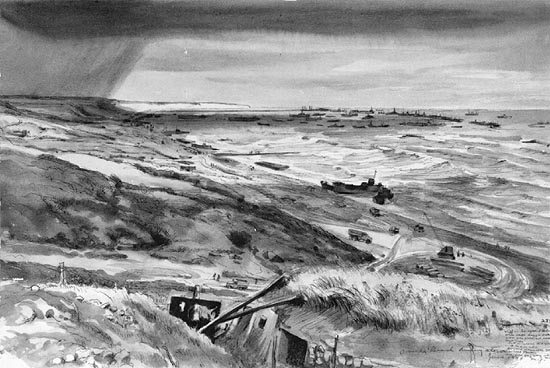
Storm from Seabee Hill
Mitchell Jamieson #232
Ink & wash, June 1944
88-193-IJ
In the distance was the stretch of sheer cliff which U.S. Army Rangers scaled to get at the heavy batteries placed there, and the long strip just this side of it was the floating bridge leading out to the pierheads constructed for the unloading of ships. The line of sunken block ships, so placed as to break the surf and protect shipping, stretches to the right of the pierhead. In spite of this shelter, amphibious craft were blown ashore in great numbers. Along the length of the beach were wrecked LCIs, LCTs and pontoon sections for unloading. A little to the left of the hill, in the middle distance, there was an airstrip where wounded could be evacuated from the field hospital a little distance inland. The cemetery was situated on a hill this side of the airstrip. NOIC headquarters was on hill in the distance overlooking the beach. No unloading was possible while the gale raged, and there was nothing to do but sit tight for the moment.
 Storm,
Omaha Beach
Storm,
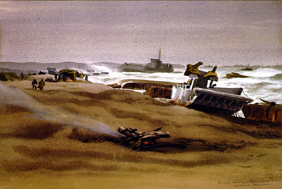
Omaha Beach
Mitchell Jamieson #275
Oil on board, circa 1944
88-193-KP
Small invasion craft were tossed about like corks in the gale that did so much damage a few weeks after D-Day.
 Storm
on "Gooseberry"
Storm
on "Gooseberry"
Dwight C. Shepler #162
Watercolor, June, 21 1944
88-199-FJ
There, with decks awash in the roaring sea, the sunken block ships of the great harbor of "Mulberry" successfully rode out the storm. The part of the breakwater formed by the line of sunken ships was called "Gooseberry." Though they worked about on the bottom, the ships held their place throughout the unseasonal blow of June 19-22, 1944. At the height of the gale's fury, gunners stationed on a sunken merchantman sought safety on the fo'c'sle of the H.M.S. Centurion, an old British battlewagon which was the western bastion of Gooseberry.
 Beach
in Normandy During Storm
Beach
in Normandy During Storm
Mitchell Jamieson #233
Watercolor, circa 1944
88-193-IL
A heavy storm stopped all unloading at the beaches and did considerable damage several days after D-Day. This view looked east along a stretch of the westernmost of the two American beaches during the worst period, when all types of small craft were blown ashore, together with pontoon barges and "rhinos," in one gigantic mass. Many small craft sought the shelter of the block ships, and when their anchors would not hold they were forced onto the beach en mass, knocking great gaping holes in each other. A beached LCM and pontoon sections are in the foreground, and in the background are a wrecked LCI and more small amphibious craft.
 During
the Storm
During
the Storm
Mitchell Jamieson #V-75
Charcoal & wash, June 1944
88-193-TB
Wreckage of the pontoon causeway.
 The
End of Mulberry "A"
The
End of Mulberry "A"
Dwight C. Shepler #161
Watercolor, 1944
88-199-FI
Below the bluff of the Omaha beachhead, the twisted relic of the fabulous artificial harbor of Mulberry filled the sea. The row of concrete caissons paralleling the shore finally disintegrated on the third day of the great storm of June 19-22, 1944, letting the seas though to break up the floating piers.
1 2 3 4 5 6 7 8 9 10 11 12 13 14 15 16 17 18 19 20 21 22 23 24 25